Property Editor - Style Object
The Style Property Editor provides a dialogue to edit the properties of a style object. Classes can have one or more styles. Multiple styles can be combined to create complex symbolgy or to show different style at different scale ranges. The styles are rendered sequentially when the class is drawn. The Style Property Editor contains a sample window to show how the style will finally be rendered with the layer.
While the style property editor can be used to create custom styles it can also be used to select styles predefined in the MapManager Style Library which is now the central repository of the predefined styles.
Construction of style for Point, Line and Polygon features use the feature set provided in the Style Property Editor. For example Symbol Size is used for point feature symbols size but also for symbols within fill patterns. Symbol Size, Angle, Line Widths amongst other parameters all have impact on the rendering of patterns used within Polygons. For information on how to construct styles please see: Cartographical Symbol Construction with MapServer
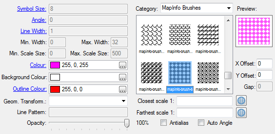
- Symbol Size - The height, in layer SIZEUNITS, of the symbol/pattern to be used. Only useful with scalable symbols. For symbols of Type HATCH, the SIZE is the distance between hatched lines. This parameter is bindable. For more information about the style attribute binding see: Using the MapServer Label and Style Property Binding
- Angle - Specifies the angle of the symbol. For symbols of Type HATCH, this is the angle of the hatched lines. This parameter is bindable. For more information about the style attribute binding see: Using the MapServer Label and Style Property Binding
- Line Width - Width refers to the thickness of line drawn, in layer SIZEUNITS. For symbols of Type HATCH, the width shows how thick the hatched lines are. This parameter is bindable. For more information about the style attribute binding see: Using the MapServer Label and Style Property Binding
- Min Width - Minimum width in layer SIZEUNITS to draw the line when the scale dependent sizing is enabled (i.e.. by specifying the symbolscale parameter in Style tab of the Layer Property Editor)
- Max Width - Maximum width in layer SIZEUNITS to draw the line when the scale dependent sizing is enabled (i.e.. by specifying the symbolscale parameter in Style tab of the Layer Property Editor)
- Min Scale Size - The minimum Symbol Size of the style when the scale dependent sizing is enabled (i.e.. by specifying the symbolscale parameter in Style tab of the Layer Property Editor)
- Max Scale Size - The maximum Symbol Size of the style when the scale dependent sizing is enabled (i.e.. by specifying the symbolscale parameter in Style tab of the Layer Property Editor)
- Colour - Colour to use for drawing features. The colour can be selected with the Colour Selector control. This parameter is bindable. For more information about the label attribute binding see: Using the MapServer Label and Style Property Binding
- Background Colour - Colour to use for non-transparent background of the symbols. The colour can be selected with the Colour Selector control.
- Outline Colour - Colour to use for outlining polygons and certain marker symbols. Line symbols do not support outline colours. The colour can be selected with the Colour Selector control. This parameter is bindable. For more information about the label attribute binding see: Using the MapServer Label and Style Property Binding
- Geom Transform - Used to indicate that the current feature will be transformed before the actual style is applied. The following geometry transformations can be selected:
- start - Transforms the geometry to a Point feature at the location of the first vertex. When used with 'auto angle', it can for instance be used to render arrow tails on line segments
- end - Transforms the geometry to a Point features at the location of the last vertex. When used with 'auto angle', it can for instance be used to render arrowheads on line segments
- vertices - Produces all the intermediate vertices of the current feature geometry (the start and end are excluded). When used with 'auto angle', the marker is oriented by the half angle formed by the two adjacent line segments
- bbox - Produces the bounding box of the current feature geometry
- centroid - Produces the centroid of the current feature geometry
- labelpoly - [Used for label styles only] - Produces a polygon that covers the label plus a 1 pixel padding.
- labelpnt - [Used for label styles only] - Draws a marker on the geographic position the label is attached to. This corresponds to the centre of the label text only if the label is in position MS_CC.
- <expression> - Applies the given expression to the geometry. Supported expressions:
Buffer the geometry ([shape]) using dist pixels as buffer distance. For polygons, a negative dist will produce a setback.
(buffer([shape], dist))
- Line Pattern - Used to define a dash pattern for line symbols. Patterns should be defined as a sequence of numeric values according to the length of the dashes and gaps in layer size units, like: '10.2 0.5 4.2 0.5'
- Opacity - Opacity to draw the current style. Currently supported by the AGG output formats
- Category - Provides the list of the style categories defined in the Style Library. The styles of the specified category can be selected in the style list right below the category combo.
- X Offset - Horizontal offset values for shadows, hollow symbols, etc.
- Y Offset - Vertical offset values for shadows, hollow symbols, etc.
- Gap - Specifies the distance between symbols (centre to centre) for decorated lines and polygon fills in layer 'size units'. For polygon fills, gap specifies the distance between symbols in both the X and the Y direction. For lines, the centres of the symbols are placed on the line. For more information about this setting please refer to the MapServer STYLE documentation
- Closest scale - The closest scale at which the class is drawn when setting up the scale dependent rendering. Clicking on the
 button we can set the current scale of the map
- Farthest scale - The farthest scale at which the class is drawn when setting up the scale dependent rendering. Clicking on the
 button we can set the current scale of the map
- Antialias - AntiAliasing for TrueType fonts and Cartoline symbols where available - has no effect where Antialias is not possible
- Auto Angle - Setting 'Auto Angle' allows MapServer to compute the angle. Currently only applies when coupled with the 'Geom Transform' setting.